show
This article may be expanded with text translated from the corresponding article in French. (July 2014) Click [show] for important translation instructions.
|
| Seine | |
|---|---|

The Seine in Paris
| |
.png)
Topographic map of the Seine basin
| |
| Location | |
| Country | France |
| Physical characteristics | |
| Mouth | |
- coordinates
| 49°26′02″N 0°12′24″ECoordinates: 49°26′02″N 0°12′24″E |
- elevation
| 0 m (0 ft) |
| Length | 777 km (483 mi) |
| Basin size | 79,000 km2 (31,000 sq mi) |
| Discharge | |
| - location | Le Havre |
| - average | 560 m3/s (20,000 cu ft/s) |
| Basin features | |
| Tributaries | |
| - left | Yonne, Loing, Eure, Risle |
| - right | Ource, Aube, Marne, Oise, Epte |

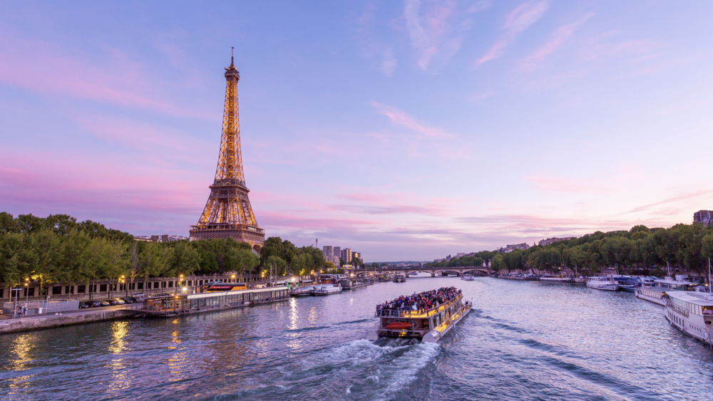
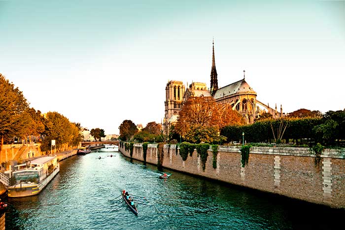
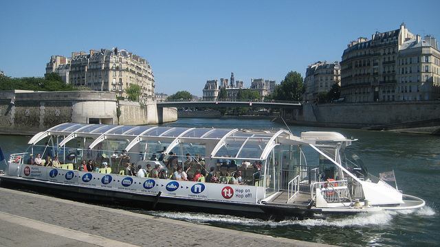
The Seine (/seɪn/ SAYN, French: [sɛːn] ( listen)) is a 777-kilometre-long (483 mi) river and an important commercial waterway within the Paris Basin in the north of France. It rises at Source-Seine, 30 kilometres (19 mi) northwest of Dijon in northeastern France in the Langres plateau, flowing through Paris and into the English Channel at Le Havre (and Honfleur on the left bank).[1] It is navigable by ocean-going vessels as far as Rouen, 120 kilometres (75 mi) from the sea. Over 60 percent of its length, as far as Burgundy, is negotiable by commercial riverboats, and nearly its whole length is available for recreational boating; excursion boats offer sightseeing tours of the river banks in Paris, lined with top monuments including Notre-Dame, the Eiffel Tower, the Louvre Museum and Musée d'Orsay.[2]
There are 37 bridges within Paris and dozens more spanning the river outside the city. Examples in Paris include the Pont Alexandre III and Pont Neuf, the latter of which dates back to 1607. Outside the city, examples include the Pont de Normandie, one of the longest cable-stayed bridges in the world, which links Le Havre to Honfleur.
Sources[edit]

The Seine rises in the commune of Source-Seine, about 30 kilometres (19 mi) northwest of Dijon. The source has been owned by the city of Paris since 1864. A number of closely associated small ditches or depressions provide the source waters, with an artificial grotto laid out to highlight and contain a deemed main source. The grotto includes a statue of a nymph, a dog, and a dragon. On the same site are the buried remains of a Gallo-Roman temple. Small statues of the dea Sequana "Seine goddess" and other ex voti found at the same place are now exhibited in the Dijon archaeological museum.
Course[edit]
The Seine can artificially be divided into five parts:
- the Petite Seine "Small Seine" from the sources to Montereau-Fault-Yonne
- the Haute Seine "Upper Seine" from Montereau-Fault-Yonne to Paris
- the Traversée de Paris "the Paris waterway"
- the Basse Seine "Lower Seine" from Paris to Rouen
- the Seine maritime "Maritime Seine" from Rouen to the English channel.
[edit]

The Seine is dredged and ocean-going vessels can dock at Rouen, 120 kilometres (75 mi) from the sea. Commercial craft (barges and push-tows) can use the river from Marcilly-sur-Seine, 516 kilometres (321 mi) to its mouth.[3]
At Paris, there are 37 bridges. The river is only 24 metres (79 ft) above sea level 446 kilometres (277 mi) from its mouth, making it slow flowing and thus easily navigable.
The Seine Maritime, 123 kilometres (76 mi) from the English Channel at Le Havre to Rouen, is the only portion of the Seine used by ocean-going craft.[4] The tidal section of the Seine Maritime is followed by a canalized section (Basse Seine) with four large multiple locks until the mouth of the Oise at Conflans-Sainte-Honorine (170 km). Smaller locks at Bougival and at Suresnes lift the vessels to the level of the river in Paris, where the junction with the Canal Saint-Martin is located. The distance from the mouth of the Oise is 72 km.[5]
The Haute Seine, from Paris to Montereau-Fault-Yonne, is 98 km long and has 8 locks.[6] At Charenton-le-Pont is the mouth of the Marne. Upstream from Paris seven locks ensure navigation to Saint Mammès, where the Loingmouth is situated. Through an eighth lock the river Yonne is reached at Montereau-Fault-Yonne. From the mouth of the Yonne, larger ships can continue upstream to Nogent-sur-Seine (48 km, 7 locks).[7] From there on, the river is navigable only by small craft to Marcilly-sur-Seine (19 km, 4 locks).[8] At Marcilly-sur-Seine the ancient Canal de la Haute-Seine used to allow vessels to continue all the way to Troyes. This canal has been abandoned since 1957.[9]
The average depth of the Seine today at Paris is about 9.5 metres (31 ft). Until locks were installed to raise the level in the 1800s, the river was much shallower within the city most of the time, and consisted of a small channel of continuous flow bordered by sandy banks (depicted in many illustrations of the period). Today the depth is tightly controlled and the entire width of the river between the built-up banks on either side is normally filled with water. The average flow of the river is very low, only a few cubic metres per second, but much higher flows are possible during periods of heavy runoff. Special reservoirs upstream help to maintain a constant level for the river through the city, but during periods of extreme runoff significant increases in river level may occur.
Flooding[edit]
A very severe period of high water in January 1910 resulted in extensive flooding throughout the city. The Seine again rose to threatening levels in 1924, 1955, 1982, 1999–2000, June 2016, and January 2018.[10][11] After a first-level flood alert in 2003, about 100,000 works of art were moved out of Paris, the largest relocation of art since World War II. Much of the art in Paris is kept in underground storage rooms that would have been flooded.[12] A 2002 report by the French government stated the worst-case Seine flood scenario would cost 10 billion euros and cut telephone service for a million Parisians, leaving 200,000 without electricity and 100,000 without gas.[13]
2018 Paris flood[edit]
In January 2018 the Seine again flooded, reaching a flood level of 5.84 metres (19 ft 2 ins) on 29 January.[14] An official warning was issued on January 24 that heavy rainfall was likely to cause the river to flood.[15] By January 27, the river was rising.[16] The Deputy Mayor of Paris, Colombe Brossel, warned that the heavy rain was caused by climate change, and that "We have to understand that climatic change is not a word, it's a reality."[17]
Watershed[edit]
The basin area is 78,910 square kilometres (30,470 sq mi),[18] 2 percent of which is forest and 78 percent cultivated land. In addition to Paris, three other cities with a population over 100,000 are in the Seine watershed: Le Havre at the estuary, Rouen in the Seine valley and Reims at the northern limit—with an annual urban growth rate of 0.2 percent.[18] The population density is 201 per square kilometer.
Water quality[edit]
Periodically the sewerage systems of Paris experience a failure known as sanitary sewer overflow, often in periods of high rainfall. Under these conditions untreated sewage is discharged into the Seine.[19] The resulting oxygen deficit is principally caused by allochthonousbacteria larger than one micrometre in size. The specific activity of these sewage bacteria is typically three to four times greater than that of the autochthonous (background) bacterial population. Heavy metal concentrations in the Seine are relatively high.[20] The pH level of the Seine at Pont Neuf has been measured to be 8.46. Despite this, the water quality has improved significantly over what several historians at various times in the past called an "open sewer".[21]
In 2009, it was announced that Atlantic salmon had returned to the Seine.[22]
History[edit]

Name[edit]
The name Seine comes from the Latin Sēquana, the Gallo-Roman goddess of the river.
Events[edit]
On 28 or 29 March, 845, an army of Vikings led by a chieftain named Reginherus, which is possibly another name for Ragnar Lothbrok, sailed up the River Seine with siege towers and sacked Paris.
On 25 November, 885, another Viking expedition led by Rollo was sent up the River Seine to attack Paris again.
In March, 1314, King Philip IV of France had Jacques de Molay, last Grand Master of the Knights Templar, burned on a scaffold on an island in the River Seine in front of Notre Dame de Paris.[23]
After the burning at the stake of Joan of Arc in 1431, her ashes were thrown into the Seine from the medieval stone Mathilde Bridge at Rouen, though unserious counter-claims persist.[24]
According to his will, Napoleon, who died in 1821, wished to be buried on the banks of the Seine. His request was not granted.
At the 1900 Summer Olympics, the river hosted the rowing, swimming, and water polo events.[25] Twenty-four years later, it hosted the rowing events again at Bassin d'Argenteuil, along the Seine north of Paris.[26]
Until the 1930s, a towing system using a chain on the bed of the river existed to facilitate movement of barges upriver.[citation needed] World Canals by Charles Hadfield, David and Charles 1986
The Seine was one of the original objectives of Operation Overlord in 1944. The Allies' intention was to reach the Seine by 90 days after D-Day. That objective was met. An anticipated assault crossing of the river never materialized as German resistance in France crumbled by early September 1944. However, the First Canadian Army did encounter resistance immediately west of the Seine and fighting occurred in the Forêt de la Londe as Allied troops attempted to cut off the escape across the river of parts of the German 7th Army in the closing phases of the Battle of Normandy.
Some of the Algerian victims of the Paris massacre of 1961 drowned in the Seine after being thrown by French policemen from the Pont Saint-Michel and other locations in Paris.
Dredging in the 1960s mostly eliminated tidal bores on the lower river, known in French as "le mascaret."
In 1991 UNESCO added the banks of the Seine in Paris—the Rive Gauche and Rive Droite—to its list of World Heritage Sites in Europe.[27]
Since 2002 Paris-Plages has been held every summer on the Paris banks of the Seine: a transformation of the paved banks into a beach with sand and facilities for sunbathing and entertainment.
The river is a popular site for disposal of bodies of murder victims.[28] In 2007, 55 bodies were retrieved from its waters; in February 2008, the body of supermodel-turned-activist Katoucha Niane was found there.[28]
In fiction[edit]
The Seine was the river that Javert, the primary antagonist of Victor Hugo's 1862 novel Les Misérables drowned himself in.
In art[edit]
During the 19th and the 20th centuries in particular the Seine inspired many artists, including:
- Frédéric Bazille
- Maurice Boitel
- Richard Parkes Bonington
- Eugène Boudin
- Camille Corot
- Charles-François Daubigny
- Guy Debord
- Raoul Dufy
- Othon Friesz
- Carl Fredrik Hill
- Eugène Isabey
- Johan Barthold Jongkind
- Raimond Lecourt
- Albert Marquet
- Henri Matisse
- Claude Monet
- Luis F. Pinzón
- Camille Pissarro
- Emilio Grau Sala
- Gaston Sébire
- Georges-Pierre Seurat
- Alfred Sisley
- Constant Troyon
- J. M. W. Turner
- Félix Vallotton
- Édouard Vuillard
A song 'La Seine' by Flavien Monod and Guy Lafarge was written in 1948.
Josephine Baker recorded a song 'La Seine' [29]
A song 'La seine' by Vanessa Paradis feat. Matthieu Chedid was originally written as a soundtrack for the movie 'A Monster in Paris'


Websites for information
https://www.vikingrivercruisescanada.com/cruise-destinations/europe/rivers/seine/index.html
https://www.bateauxparisiens.com/en/cruise-tours.html
Tips & Hints
River Seine
·
Paris Batobus service is operated in the city
giving easy access to places like Eiffel tower, Notredam cathedral and louver
museum by using this river.
·
In the evenings floating restaurants operated
in the river.
·
Lots of cruise options available in this river
Public Transportation- Hop & Hop
http://www.batobus.com/
Disclaimer
The above
comments are based on my personal travel experiences to this particular
location in summer months. Your experience may vary due to weather and traffic.
My trips were not
sponsored by any of the authorities and my comments are not biased or
representing any views of governing bodies.
History and
information extracted from Wikipedia and photos were selected from Google
images and all rights reserved with original owners.
This is only for
an informational purpose. Not for commercial use.
Note.


